
We are deep into November with winter around the corner. Anticipation is ramping up for the snowmobiling season!
With data rolling in, I’m honing my Winter 2026-27 “Outlook”
Crafting an outlook involves looking for patterns and probabilities that may shape the direction of winter. It does not answer whether there will be good snowmobiling on a particular day or week.
ENSO Update
The current El Niño event is already the strongest on record for Niño 3.4 region during the satellite monitoring era.
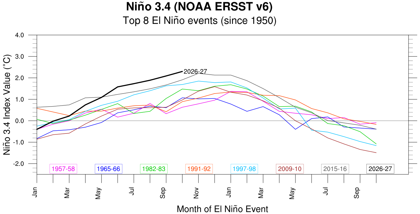
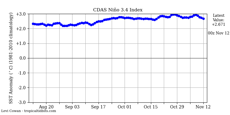
“Index value” differs somewhat from actual anomaly value, which approached +3*C and sat near +2.67*C on November 12th.
The connection between the previous two record-setting El Niño events (1997-98 and 2015-16) and mild winters for the northeastern United States is beyond any debate. I will not further beat a dead horse here.
This report is brought to you by Mangino Chevrolet Buick GMC in Amsterdam, NY & Ballston Spa, NY. We know that you have high expectations, and as a car dealer we enjoy the challenge of meeting and exceeding those standards each and every time. Allow us to demonstrate our commitment to excellence! Our experienced sales staff is eager to share its knowledge and enthusiasm with you. We encourage you to browse our online inventory, schedule a test drive and investigate financing options.
Gathering evidence
Autumn is time to observe what’s happening on a continental scale. It’s opportunity to see things that long range seasonal models can’t pick up during summer.
Lagging snow cover advance
North Hemisphere snow cover expanse was an eye-popping 15% behind climo to start November. The advance flat-lined during the first week.
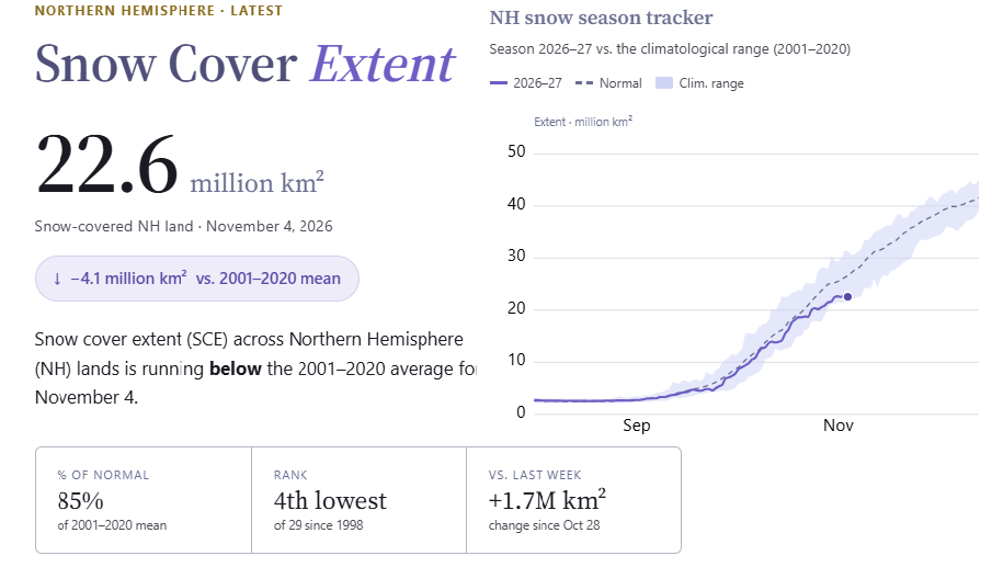
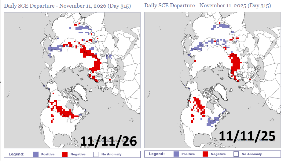
There is obvious snow coverage deficit over North America, especially compared to last year for southeast Canada into the eastern USA! Winter is struggling to make its southward push.
Eurasian Dipole Pattern?
This phenomena is manifested by lagging snow cover spread into Europe from Siberia through autumn. It was also present before last winter, which was notably cold over the eastern United States.
I caution against blindly cutting and pasting into this winter. Last winter was La Niña. The Eurasian dipole pattern that signaled a persistent deep freeze last winter may not have a similar outcome this time.
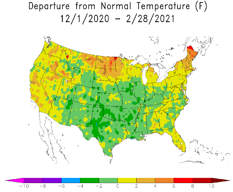
Throwing more mud into the water: A strong Eurasian dipole pattern was observed in 2020. The following winter was not very cold over the northeast United States. Seasonal snowfall was only 86.0 inches in Indian Lake, NY – well below climo.
Dr. Judah Cohen was a leading pioneer of linking autumn spread of Eurasian snow cover to North American seasonal winter forecasting. He has since expressed doubt in that connection.
Dr. Judah Cohen
I readily admit the relationship between snow cover extent, Sudden Stratospheric Warmings (SSW) and the Arctic Oscillation (AO) has dropped off to the point that it is probably no longer useful or barely useful in making a winter AO or North Atlantic Oscillation (NAO) forecasts. This has probably been true since the mid 2010’s. The key transition year seems to be 2013. It worked quite well before that year and then became no better than a coin flip after that year.
In face of the historic El Niño, I’m viewing the Eurasian dipole pattern as a nuance, not cause-and-effect.
Stratospheric Polar Vortex
An unusually early stratospheric polar vortex (SPV) split is raising speculation of Arctic outbreaks on the horizon and by extension a cold winter for the eastern United States.
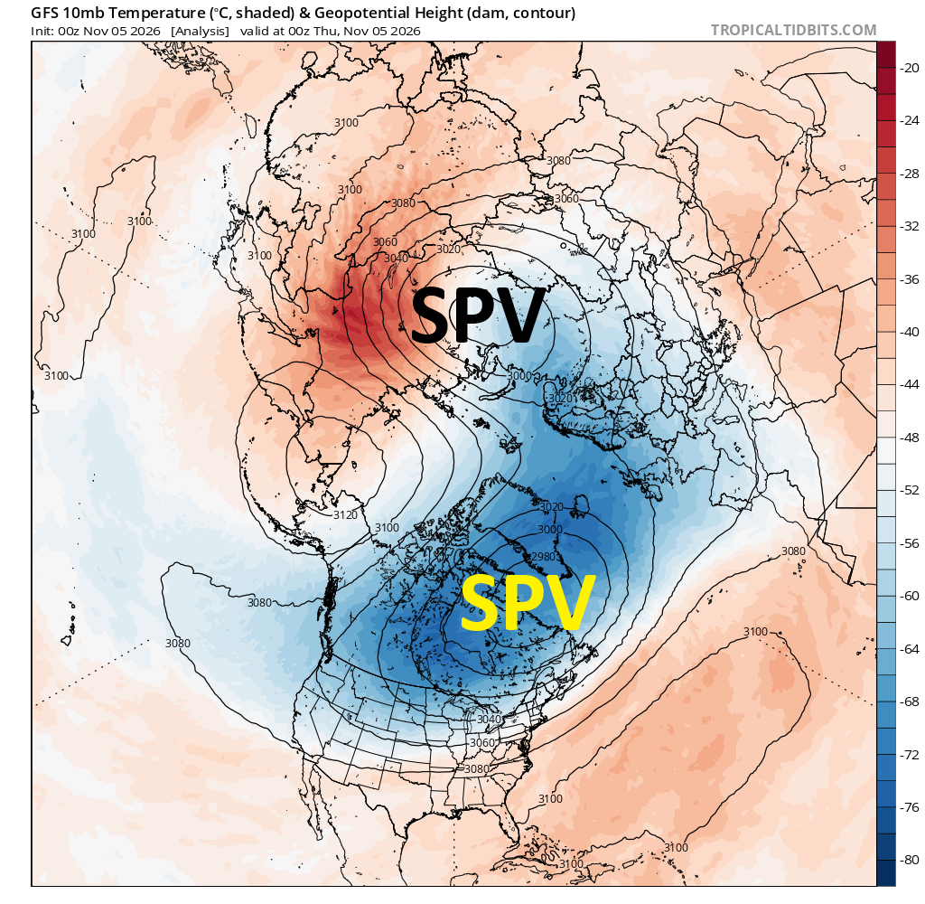
SPV splits are not permanent through winter. The stratospheric polar vortex typically splits and re-consolidates over the course of winter.
Case in point, the stratospheric polar vortex (SPV) is expected to re-consolidate over Siberia later this month.
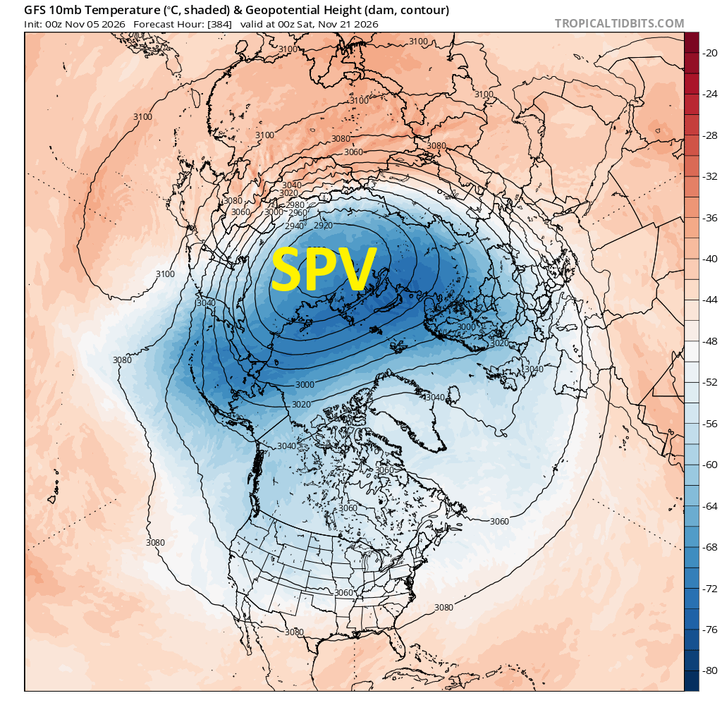
Winters when the stratospheric polar vortex remains consolidated near the North Pole for unusually long duration tend to be mild. Conversely, frequent SPV disruptions and splits present more opportunities for Arctic cold to drop southward – BUT NOT ALWAYS into the eastern United States.
SPV splits are usually associated with sudden stratospheric warming (SSW) events that are accurately forecast only a week or two in advance. That makes it a poor seasonal predictive tool.
I’m viewing the early SPV split as a nuance. Perhaps this occurrence indicates a greater possibility for an increased number of such events this winter. But then again, perhaps not.
On to long range modelology!
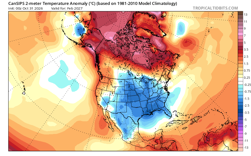
CanSIPS winter seasonal outlook certainly reeks of El Niño, with relative warmth favored along USA northern tier. Forecast mean temperature anomaly for central Adirondacks is about +1.7*C or +3.0*F over the whole winter (Dec-Jan-Feb).
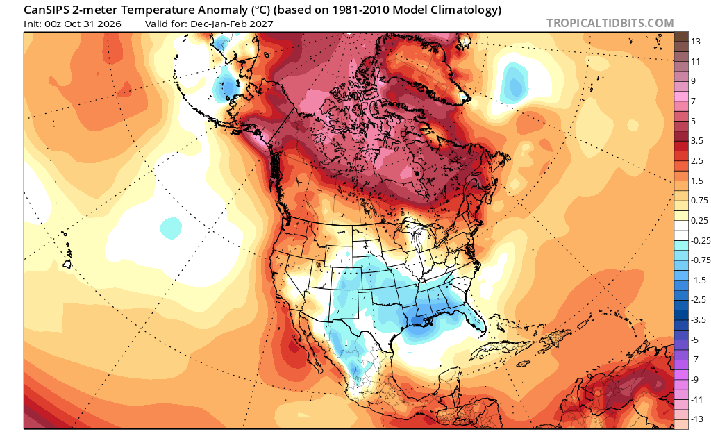
On face value, +3*F looks awful. But I’m about to flash some more nuance at you!
CanSIPs shows relative warmth focused over the Canadian Arctic. The composite of analogue years (based on worldwide sea surface temperature) shows the warmth focused much further south.
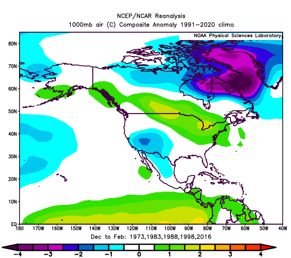
Canadian Arctic “warmth” could indicate high-latitude blocking episodes this winter. This may funnel more cold shots into the eastern USA than typically occurring during strong El Niño winters. But there will be times when North America becomes devoid of any true Arctic air. Some new record daily high temperatures would not surprise me.
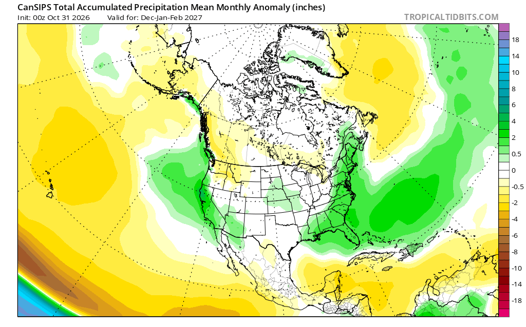
CanSIPs also shows notably “wet” precipitation anomaly over eastern United States, implying an active coastal storm track.
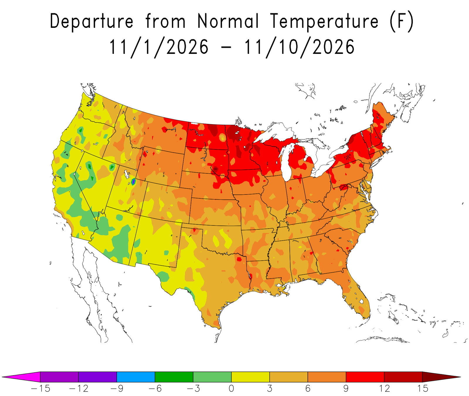
This will be a historic El Niño winter, but with nuance. How quickly can we transition from the November death lock? That may take us longer than we’d wish, given STRONG WARMTH over the bulk of the United States to begin November.
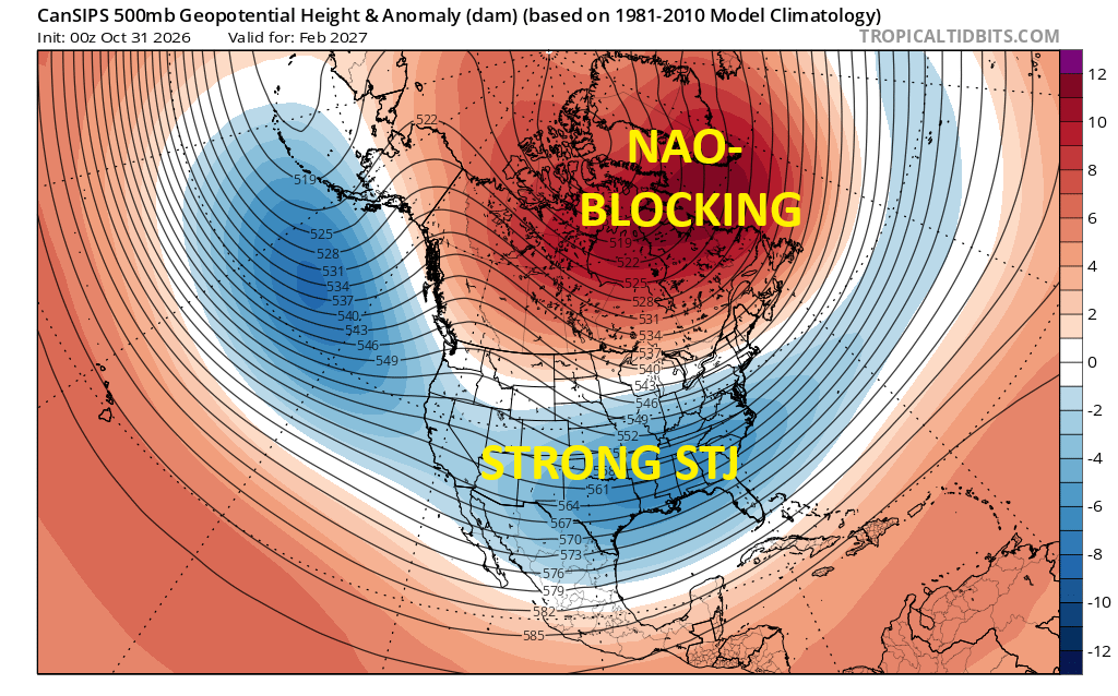
February appears especially promising with optimal North Atlantic blocking position (NAO-) and a strong subtropical jet (STJ). Could also be the coldest month this winter, relative to climo.
Bottom line
Unfolding events have reinforced my speculation since late August. Added nuances increase my confidence for an active and snowy (at times) winter, despite the overall warmth associated with a record-setting El Niño.
For central Adirondacks, I expect December-January-February to average 2-3*F MILDER than climatology. Total 2026-27 seasonal snowfall should be NEAR OR SOMEWHAT HIGHER than climatology. Climo seasonal snowfall for Indian Lake is 111 inches.
Yes, ilsnow land can have mild winters with abundant seasonal snowfall! They have occurred as recently as 2016-17 (129.6″ snow at Indian Lake, NY) and 2022-23 (122.5″). They are NOT analogs for this winter based on worldwide sea surface temperature. But I’ll put them up for show and tell.
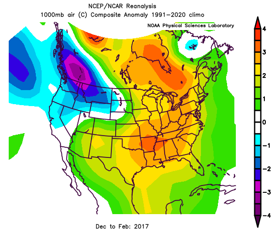
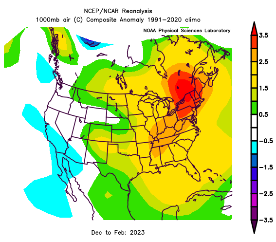
I don’t foresee an encore of 2015-16 – the previous record El Niño with a very mild winter and paltry seasonal snowfall of only 52.6 inches in Indian Lake. I bought a new 1200 4-TEC and rode it barely over 300 miles that winter. Sat in the garage with “new sled smell” the following summer. OOOOOF!!!!!
As always, we’ll see what happens.
For the ilsnow nation,
Darrin
