We’re into the time of year littered with click bait weather outlooks.
With El Niño to venture into record territory entering winter, fear mongering is approaching fever pace!
Instead of fueling the doom and gloom machine, I’ll stick to ACTUAL science and statistics to get a broad brushed read on what may happen this winter.
Let’s get a look into what’s going on NOW and play it forward.
Super Niño!
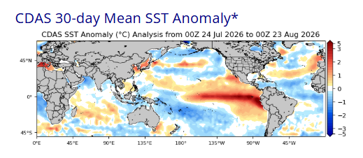
El Niño will be the dominant force across North America this winter. It is already large and in-charge with a massive warm anomaly extending across the equatorial Pacifc from the South American coast.
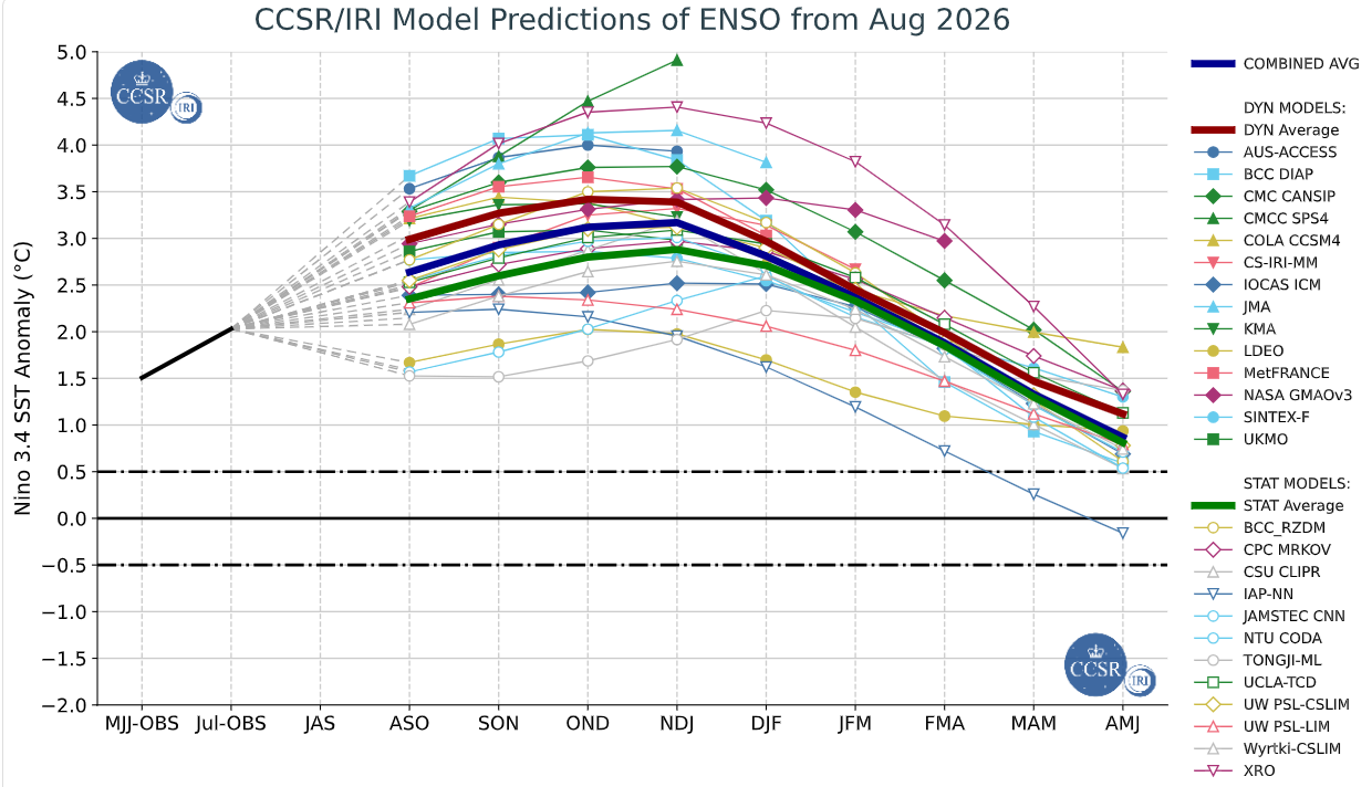
CCSR/IRI model ensemble composite is projecting peak anomaly to exceed +3*C in Niño region 3.4 in November-December-January. This would blow away 2015-16 (+2.75*C) and 1997-98 (+2.40*C) as the strongest El Niño event during the satellite monitoring era.
INCREDIBLE!
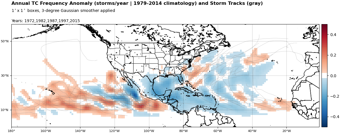
One hallmark of a strong El Niño event is weak tropical cyclone activity over Atlantic and Caribbean basins during the hurricane season. That has been very much the case this summer.
This report is brought to you by Mangino Chevrolet Buick GMC in Amsterdam, NY & Ballston Spa, NY. We know that you have high expectations, and as a car dealer we enjoy the challenge of meeting and exceeding those standards each and every time. Allow us to demonstrate our commitment to excellence! Our experienced sales staff is eager to share its knowledge and enthusiasm with you. We encourage you to browse our online inventory, schedule a test drive and investigate financing options.
Does that mean NO SNOW?
Of course not, but a strong El Niño this winter dramatically increases the likelihood of thaws and rain between snow events.
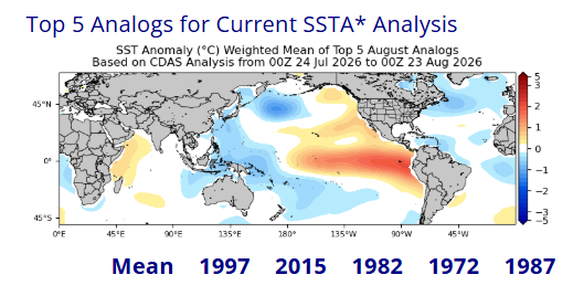
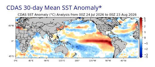
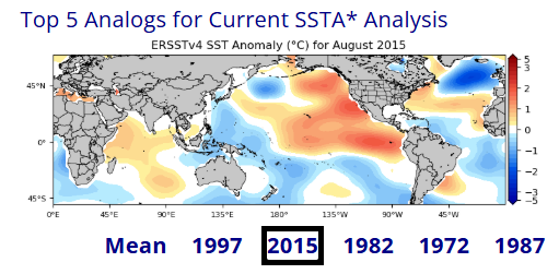
Top-5 analogs accounting for worldwide sea-surface temperature anomaly (SSTA) for the 30-day period ending August 23 in descending order are: 1997, 2015, 1982, 1972 and 1987.
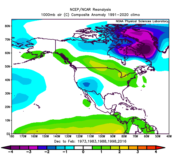
Composite mean temperature anomaly for December-January-February during the following winters was quite mild over northern tier of United States, relative to climatology. These maps were constructed in degrees Celsius. Multiply by 1.8 to translate anomalies to degrees Fahrenheit.
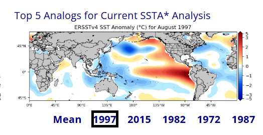
August 1997 is our best comparison for the equatorial Pacific. There are significant differences in the North Pacific, but let’s take a look.
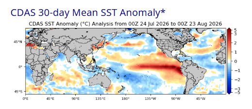
December-January-February temperature anomaly for Winter 1997-98 was quite mild. Not surprising!
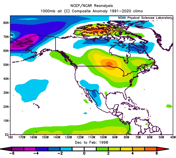
Despite relative warmth, Indian Lake, NY accumulated 103.7 inches of snowfall during 1997-98 season, not far less than climo of 111 inches. But it was a “hit-it-when-you-get it” type of winter for snowmobiling.
Special note on El Niño 2015-16
In my lifetime, 2015-16 was the “gold standard” for an AWFUL snowmobiling winter with mild temperatures and snowfall totaling only 52.6 inches at Indian Lake for the entire season.
I am hopeful that won’t be our fate this winter, if only because the entire eastern Pacific from equator to Alaska was “on fire” by August 2015.
Month by Month
We can only get so much mileage from analogs. Time to dig into some long-range ensemble modelology for additional clues on this winter!
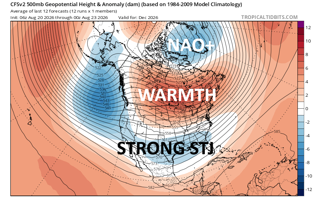
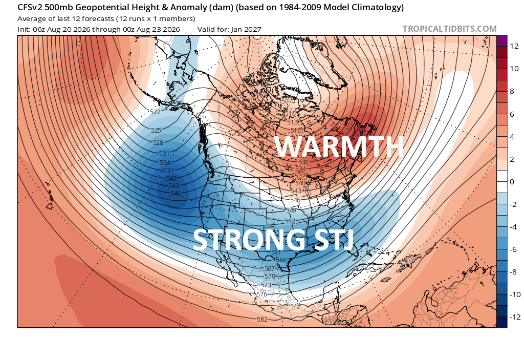
December
CFSv2 ensemble implies strongly positive-phased North Atlantic (NAO+), which would be DEATH for sustainable cold over the Great Lakes and northeast USA. This would hinder snowpack build up.
You can also see El Nino’s signature strong subtropical jet stream (STJ).
January
Not great, but CFSv2 ensemble indicates a gradual breakdown of the NAO+ death lock. Relative warmth migrating toward Canadian Maritimes may allow more room for a few cold shots from Canadian Arctic. Active subtropical jet (STJ) may bring frequent stormy weather from Deep South into middle Atlantic region.
February
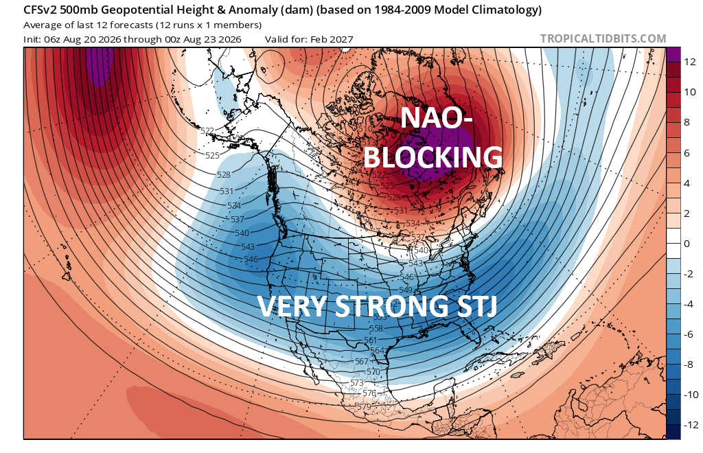
CFSv2 ensemble implies strongly negative-phased North Atlantic (NAO-) blocking regime. This would force Arctic air masses to tunnel under the block and interact with a hyperactive subtropical jet (STJ).
February and perhaps into early March may be the pick of the litter for big snow events! I don’t foresee weeks of uninterrupted cold stacked together like last winter. But at least this shows some promise for bountiful snow.
Bottom line
Of course, each winter is unique unto itself. Any seasonal forecast is at the mercy of unforeseen weather events that unfold duing the course of that season. But very strong El Niño events have a distinct warm signature over the northern tier of central and eastern United States.
For Indian Lake, NY and central Adirondacks, I believe December-January-February may average at least 2-3*F MILDER than climatology. Total 2026-27 seasonal snowfall may end up NEAR OR SOMEWHAT HIGHER than climatology, owing to enhanced possibility of a major or blockbuster snow event late winter.
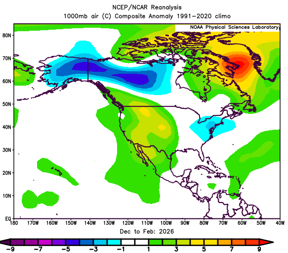
This shall be very different from last winter, which looked like this for mean temperature anomaly December-January-February:
Regardless, I’ll be ready to RIDE!
For the ilsnow nation,
Darrin
Thanks for the update Darrin. I have been waiting all summer for you to address our nemesis El Nino.
I appreciate your kind words. I had to see how the worldwide sea surface temp. anomalies evolved over summer. As we press into autumn, we’ll gather more information including snow/ice cover spread over North America.
Almost totally lost, but good summaries get me on track. Good to have you back for 26-27.
Good to be back! Finally, we’re over the hump on #summersucks.