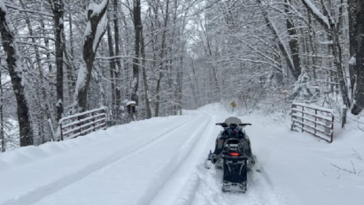
Sunday, January 7 @ 7am update: Snow far, snow good! Have 5 inches down at the ilsnow storm center in Indian Lake, NY and reports of 7 inches in Piseco and Wells.
A lull developed pre-dawn Sunday. But the radar is loading up to our southwest again with snowfall rates of 0.5″ to 1.0″ inch per hour per NY Mesonet observations. This area of enhanced snowfall will propagate through central Adirondacks today and add to the pile some more.
Happy New Year! Raise a glass to 2024’s arrival and kick 2023’s butt on its way out the door. This year couldn’t have ended up any worse for snowmobiling.
The beat goes on for our snow drought. It has gotten to the point we wonder if it will ever snow again.
But yes, it will snow again! Always returns for ilsnow land at some point.
December was particularly awful for snow lovers here and everywhere east of the Mississippi River. The lowlight of last month’s blooper reel was a 3-inch rainstorm December 17-18 that torpedoed a snowmobiling season that had barely started to grow stumpy legs.
Stats for Indian Lake, NY:
2023: Mean temperature 30.1*F, Snowfall 10.9 inches.
CLIMO: Mean temperature 20.4*F, Snowfall 22.8 inches.
2015: Mean temperature 34.3*F, Snowfall 7.3 inches.
The warm departure for 2023 was so steep, I had to double-check 2023 and climo to make sure they were both correct!
I threw in December 2015 to compare with the 2015-16 Super El Niño event. Not quite as warm this time around, but we’re definitely living in the wrong neighborhood. I had feared (since September) that El Niño would be a major player this winter.
Well, the proof is in the pudding. Witness the large expanse of missing snow cover (in red) over North America.
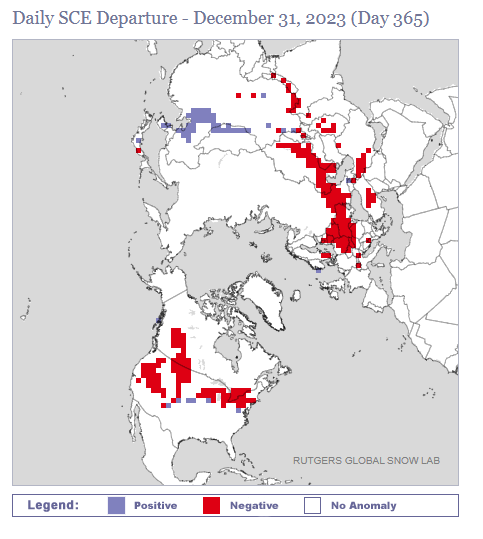
There is also a large expanse of missing snow cover into Eurasia. I don’t follow the weather in that part of the world enough to know El Niño’s effect there. But there can be no doubt over the sizeable lack of anomalous cold over the Northern Hemisphere this winter.
This report is brought to you by Wilder Performance. your one-stop-shop for high-performance, premium parts for your Snowmobile and SxS. We are riders who are passionate about off-road sports and understand the importance of having the best performance parts to enhance your riding experience. Our frustration with the lack of quick access to these parts led us to start Wilder Performance.
We believe in doing things right the first time, which is why we offer only the highest quality products, hand-picked by our team. Our location in Mayfield, NY, gives us easy access to some of the best riding trails in the Northeast, allowing us to test and fine-tune our products to provide you with the best possible performance. At Wilder Performance, we’re committed to providing exceptional customer service and delivering your orders quickly and efficiently, so you can spend less time waiting and more time riding.
Going forward
Last week, I outlined the upcoming pattern change into early January that should eventually grease the skids for winter to finally make itself known over North America. You can click here to read up on that.
This time around, I will hone in some more with the chain of events that may begin to pick snowmobiling season off the mat during the second week of January.
Thursday
A couple of weakly-defined shortwave energy systems (SW1 & SW2) will pass through on Thursday. The resultant coastal weather system should scoot out to sea, with just a light accumulation of snow expected. But this will tap into a reservoir of a climo cold (or slightly colder than climo cold) into the following weekend. Gotta start somewhere, right?
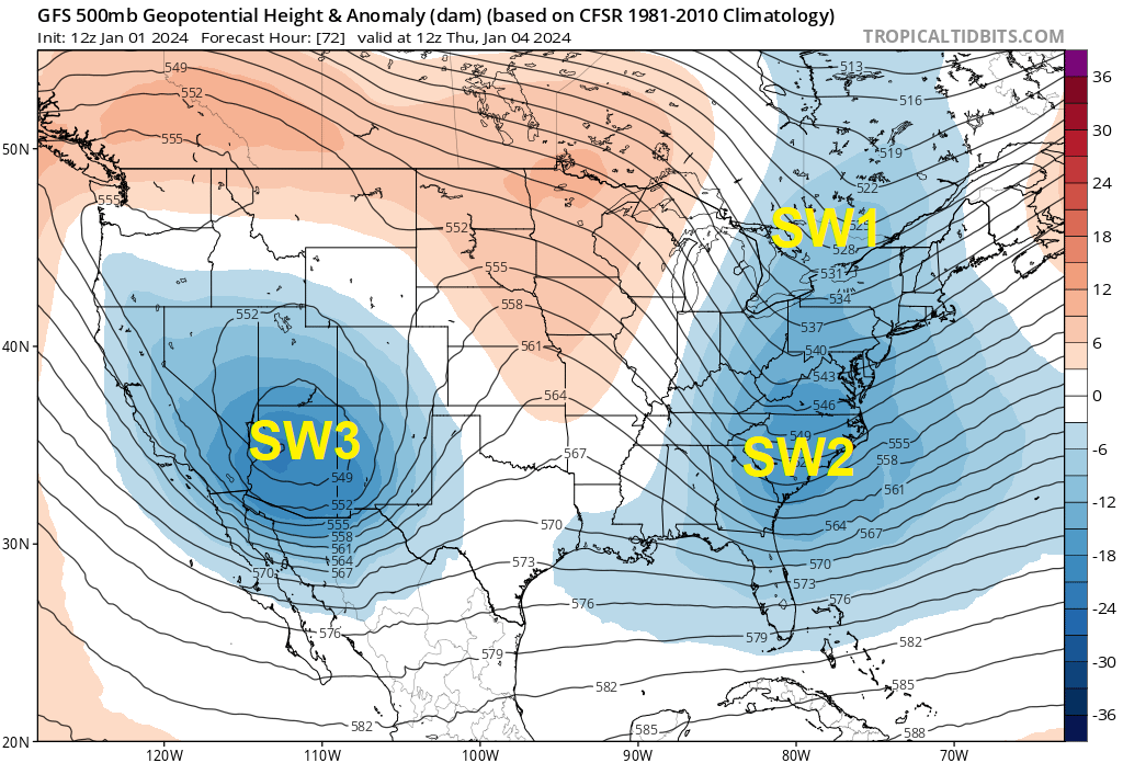
SW3 lurking over Arizona is a lurking big fish that may give us a good snow opportunity by Sunday, January 7th.
Sunday
Last night’s EPS ensemble depicted the SW3 system with good low surface pressure development over Alabama by Saturday morning. We even have cold air locked into place with high pressure over Quebec.
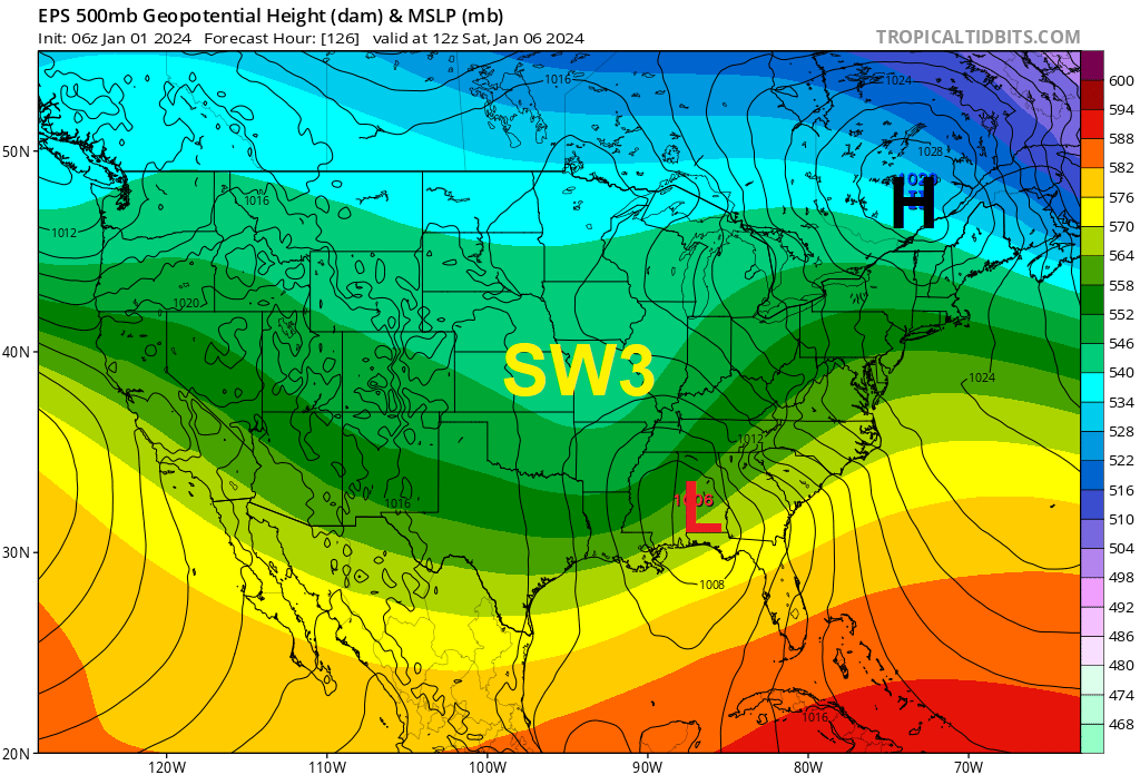
Whether this set-up can take it to the house on Sunday, January 7th with a good snow dump would depend on how well SW3 holds together on its trek across the United States. We’ll need to see how the modelology handles this as the time approaches.
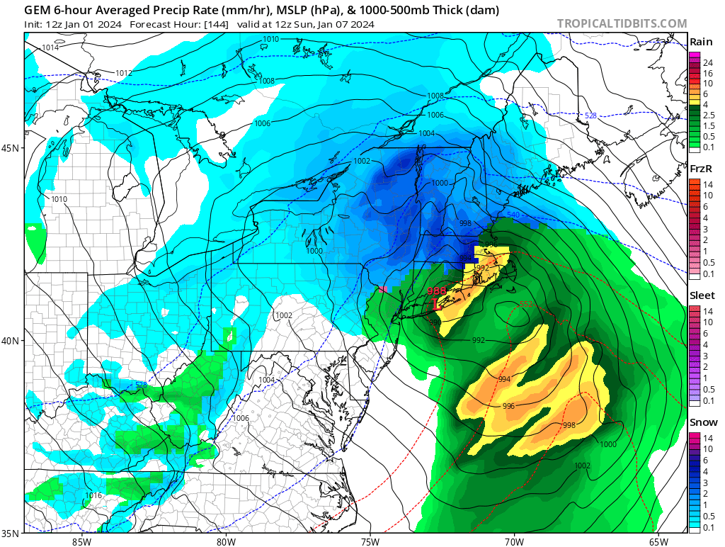
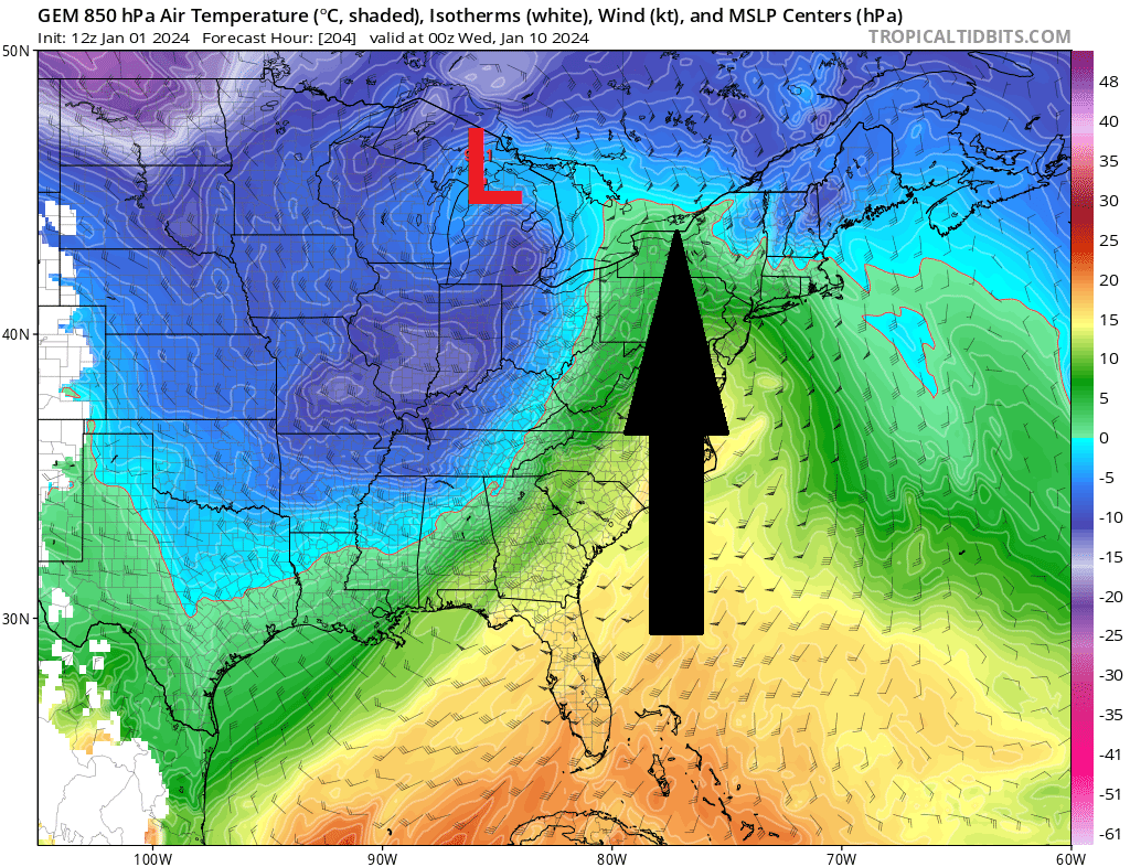
For eye-candy sake, this morning’s GEM showed something nice in progress Sunday morning.
Next week
On the heels of SW3 moving away, SW4 looks like an even bigger fish on the horizon early next week.
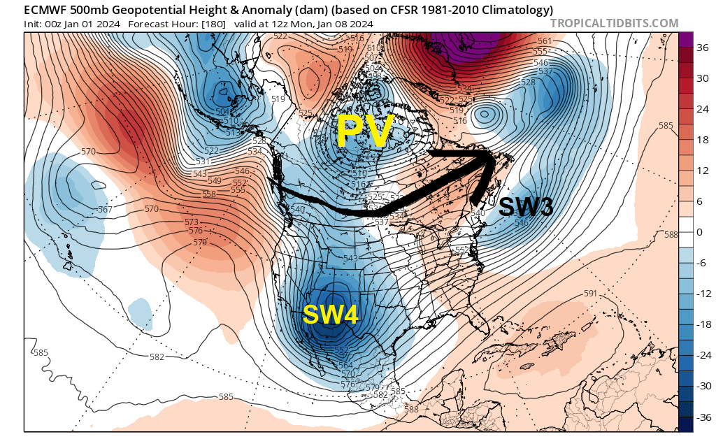
But the Polar Vortex (PV) will briefly align to develop west-east zonal flow across Canada, which would scour away cold air in advance of the next storm approaching Tuesday, January 9th. As a consequence, we’d be playing with marginal temperature profiles and a change to wintry mix/rain, before cold air floods back on Wednesday.
Indeed, today’s GEM showed the warmish punch making inroads by Tuesday evening.
After that?
We have at least a couple of camps to consider into mid-January.
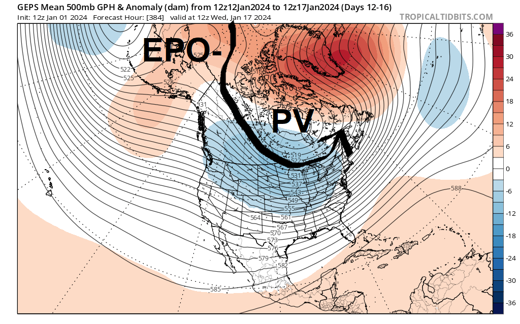
GEPS ensemble shows Polar Vortex (PV) resting over Hudson’s Bay. Good EPO- ridging over Alaska establishes excellent cross-Polar flow. Severe Arctic cold would dump into Montana, Dakotas and drain down the Rockies front range. There would be enough cold and probably snow to keep the good times rolling around here:
GEFS ensemble shows the Polar Vortex (PV) sitting west of Hudson’s Bay. The cross-Polar connection wouldn’t be as good either. This configuration may leave us vulnerable to up-and-down temperature rides:
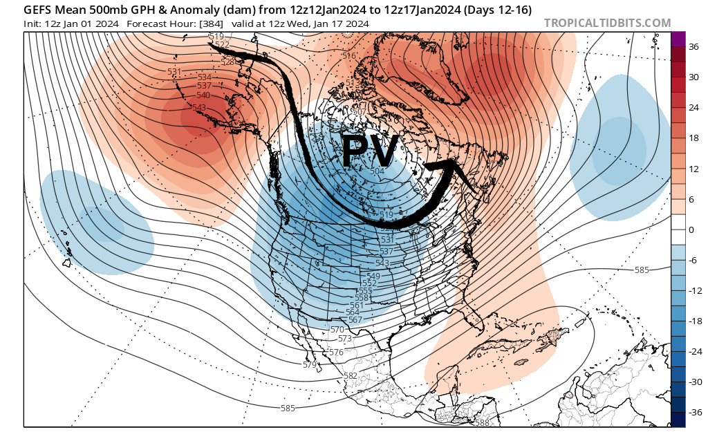
It’s a subtle difference, but one that may make a huge difference in the weather outcome for mid-January.
Beyond mid-January? Let’s get winter in through the door, then see what happens from there.
Bottom line
We’re basically a month-plus “behind schedule” and starting from scratch. Pattern change is a process, not an event. And El Niño continues to reign, large and in-charge.
There could be enough net gain to get snowmobiling going (in some form) by the weekend of January 13-14, or perhaps before that. But it won’t erase the scars from December in short order. Lakes and mudholes on narrow woods trails would still need to freeze.
For the ilsnow nation,
Darrin
If you find my posts valuable, please consider making a donation to help me keep the good times rolling! 🙂