
UPDATE 1/19/20: Almost 5 inches of dense powdery snow at the ilsnow.com storm center and still clicking away a bit. Reports of 6 inches and 6.5 inches out of Piseco and Speculator Mountain respectively – so, the really heavy snow never did develop for the southern flank of ilsnow land. But we’ve got some sorely needed points on the board. ?
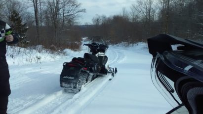
Moose River Plains, Perkins Clearing, Speculator Tree Farm, Powley Road, Newcomb trail – game on for all seasonal roads! Narrow woods trails are rideable, but you’ll need to be wary of bumps and hazards. Lakes? Well, you’ll need to defer to your best judgment on those – ice isn’t what it should be this time of year….
UPDATE 1/16/20: Looks better out there this morning with 3 inches of freshness. People have been asking about Moose River Plains. All that I can say is that a few inches of fluff on top of thin icy base and dirt spots isn’t enough for ME to bother trucking it over to Brown’s Farm to give it a shot…and I live here!
Seriously, I can’t recommend that anyone travel any real distance to ride what we’ve got now. If you’re a hard-core camper who wants to slither into camp on a beater, then go for it…I guess…
1/12/20 Report
We’ll get the easy part of this report out the door: We got virtually wiped out. That’s what 50*F warmth, heavy rain, fog and wind is supposed to do.
Snow cover ranges from bare in the open fields to upwards of several inches of remnant pack in the woods around Indian Lake. No snowmobiling for you!
OK, I’m done with stating the obvious. How do we get out of this hole? Well, let us start with a wholesale pattern change over the eastern Pacific!
The big picture…
“Pattern change” is overused, especially by click-baiters who call every passing cold front a “pattern change” to funnel traffic to their hype-sites or Youtube channels.
But the upcoming events over the next week or two will constitute a pattern change in a true sense of the word.
To start the week, this is a death grip under the stranglehold of PNA- and NAO+ teleconnections. But the large high north of Hawaii will start to arch into Alaska as the week passes on:

Look at what is to happen by the week of January 19-26! The polarity of the eastern Pacific teleconnections has nearly completely reversed with EPO- and PNA+ being manifested by ridging over the entire western North American coastline:

Check out the GEFS ensemble loop showing the evolution of the seismic pattern change:

Basic “Teleconnection 101” dictates that steep ridging over western North America translates to deep troughing over the eastern United States, hence the opportunities for repeating cold outbreaks and winter storms.
We may not get the “classic” Greenland block, but at least the NAO appears to be neutral or at worst, slightly positive. In some ways, I believe that Atlantic teleconnections are over-rated compared to Pacific teleconnections.
Playing it forward to January 26 – February 2, it’s looking favorable to keep or add to the gains that we make over the next 7-10 days:

Opportunity knocks?
Our first shot for meaningful snow to start the rebuilding process may arrive as early as Wednesday night into Thursday as a modest weather system rolls through. My best hope would be for several inches of snow to cover up the miserable ice and mud.
But the big fish in the sea would be on deck for Saturday as a vigorous storm system heads our way:
As the storm gets busy on Saturday, a mild wedge would probably work its way into western New York:

But most modelology indicates the mild push would become pinched off as the storm undergoes coastal redevelopment off-shore Maine, meaning the central Adirondacks would hold on to mostly, if not all, snow from the Saturday event.
Then we get the orographic/lake effect snows with the cold crush behind the departing storm into Sunday:

There is significant to major snow potential for Saturday into Sunday with this storm, which could put us back on the map in a big way. Plus, we can be able to keep this snow for much more than a few days. Now that would be a real pattern change, eh? 😉
I’ve been at this game for a very long time. It comes, it goes, and it comes again here in ilsnow land. The reason I get to ride until the wheels fall off is because I almost always get the snow I’m looking for, eventually…
For the ilsnow nation,
Darrin
This report has been brought to you by Rate Locker. Call Chuck at 215-964-4475 for all of your mortgage needs and tell him that Darrin @ ilsnow.com sent ya!