We dodged a bullet last weekend, but I don’t think we’ll be so lucky for the next go around. The top of the snow pack is crusty from the sleet/freezing rain mixture we got on Sunday. We did get a bit of snow mixed in, but not enough to move the needle up for us.
People who did hit Perkins Clearing and Moose River Plains last weekend did pretty well from what I heard. The Lake Pleasant Groomers have been able to pull some of the snow back onto the north end of Perkins Clearing Road so snowmobile riders would be able to hit the great stuff further back.
Looking ahead
We should get a bit of snow through Monday night, perhaps enough to freshen things up a tad for Moose River Plains and Perkins Clearing by Tuesday.
After a brief Arctic shot for Tuesday and a cold start to Wednesday, we’re going to ride the temperature train back up, bringing us to Friday’s event:

GEPS Ensembles are painting a pretty impressive storm. But with the storm center expected to track into western New York state on Friday, we’ll be on the wrong side of the track for this one. Along with rain, temperatures may easily shoot into the 40s in ilsnow land.
After the storm passes by, seasonably cold air will press over ilsnow land to staunch the bleeding over the weekend. Some orographic/lake-enhanced snows may be able to give the western Adirondacks a shot in the arm for Sunday. But the trails would be sloppy under whatever snow we may get by then.
End of 2018
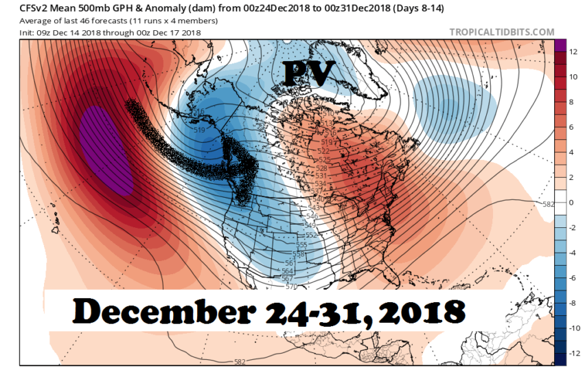
I’m going to jump ahead to take a look at the Christmas to New Year’s Eve time frame. The CFSv2 ensembles are not painting a good picture for us:

With the Polar Vortex (PV) stranded north of the Arctic Circle and a strong Pacific flow crashing into western North America, I’m hard pressed to see much help before the start of 2019.
I’m not saying it can’t snow or that it can’t get seasonably cold for a few days at a time. But whatever storms roll through here won’t have an abundance of cold air to work with and these storms may tend to track to our west.
Will this be the set-up for the rest of the winter? I don’t think so, with the warm phase PDO+ indicated by all the warm water in the Gulf of Alaska:

The warm phase PDO+ favors ridging over western North America as opposed to strong Pacific flow, more often than not. So, it’s my belief the weather pattern for the second half of December may prove to be a speed bump rather than a death knell.
El Nino?
Lest you think El Nino is the culprit for our upcoming stretch of tough sledding, the ENSO anomaly is projected to peak around 1*C for the winter, which straddles the line between weak and moderate:

We’re in a weak El Nino well into December, so time is running out for surprises on the ENSO front.
Recommendations
If you can take a mid-week day off, go ahead and take a whack at Perkins Clearing or Moose River Plains. The Newcomb trail from Indian Lake is probably not a good option as it is being plowed 4 miles in for logging.
You could poke around the Indian Lake or Speculator village trails, but that’s probably too tedious to be worth it.
And I recommend that you stay OFF the lakes for now…
Then, do your best snow dance!
For the ilsnow nation,
Darrin
This report is brought to you by Pilot Knob Marina in Lake George. Just get off Northway I-87 Exit 20, then follow NY Route 149 East until you hit the junction of NY Route 149 and Bay Road. Pilot Knob Marina features a wide selection of new and pre-owned Arctic Cat snowmobiles & ATVs. If you see Nick Barber, tell him that Darrin @ ilsnow.com sent ya!


