
Now that we’ve had some true autumn cold with our first snow flakes of the season, let’s look into what may be ahead for the winter.
Before I dive into the long-range, I want to reiterate that I don’t believe seasonal weather forecasts are accurate enough to be useful for planning your snowmobiling vacations in advance. People will tell me that Joe Blow or Jane Doe issues very accurate seasonal outlooks. Chances are, I’m already reading their work out of curiosity.
If predicting weather events 7-10 days away can be scatter-shot, how can we reasonably expect to nail seasonal outlooks? Doesn’t make sense, right?
Before we look forward, let’s get a handle on what will happen in the near future, then play it forward:
This week:
Our weather pattern for the next several days will be dominated by a series of cold Canadian Clipper systems. The highlight will be this textbook drop-and-drive cold blast for Wednesday, funneling an Arctic air-mass right at us:

The Real Fun?
All that cold may set up the stage for a significant coastal storm by Sunday as a large and powerful jet-stream trough carves its way toward the eastern United States, with a cold Canadian high pressure cell over eastern Canada:

If this was winter, or even a month later, I’d be really excited about a significant snow possibility. However, being late October, this would likely be a cold rain, or a rain-changing-to-wet-snow scenario. At any rate, we may have some power players taking the field soon.
The ensembles have been strongly suggesting this over the past several days. Also, the Arctic and North Atlantic Oscillations are forecast to cliff-dive this week, giving the idea of a significant coastal storm some serious legs:

After that?
In the wake of that storm, we’ll be under a cold northwesterly flow by default for several days into early November. But the mean trough position is likely to regress westward at some point after November 3rd, bringing cold and occasionally stormy weather from the Rockies into the upper-Midwest. The cold shots will no longer be directed squarely at us:

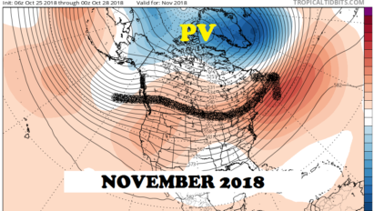
Although that will end our fun for a while, strong Polar Vortex (PV) activity will continue to build up the snow cover over south-central Canada. This may be good for us in the long run as we cross into winter, allowing colder and colder shots to hit us, once the mean trough position pushes eastward again.
How about this winter?
At the risk of sounding like a broken record, I’ll start with a familiar disclaimer:
Before I dive into the long-range, I want to reiterate that I don’t believe seasonal weather forecasts are accurate enough to be useful for planning your snowmobiling vacations in advance. People will tell me that Joe Blow or Jane Doe issues very accurate seasonal outlooks. Chances are, I’m already reading their work out of curiosity.
If predicting weather events 7-10 days away can be scatter-shot, how can we reasonably expect to nail seasonal outlooks? Doesn’t make sense, right?
Got it? 😉
Let’s look at some factors that may or may not help us.
El Nino
Shining the light on the 800 pound gorilla in the room: El Nino!
I’ve been hearing chatter on how this winter could be ruined by El Nino. At this point, the consensus of ensemble forecasts (green line) indicate a weak to borderline moderate El Nino (ENSO) for Winter 2018-19:

Other moderate El Nino years since 1980 were: 1986-87, 1994-95, 2002-03, and 2009-10. A mixture of great and not-so-great winters in that bag. A special point about 2009-10: Snowfall was well below par in ilsnow land, but the middle Atlantic region got unmercifully crushed under record snowfall in February.
So, having a moderate El Nino likely allows other factors to play into how winter may turn out. The major strong El Ninos that tend to really screw up winter occur 15-18 years apart: 1982-83, 1997-98 and 2015-16. Of course, we remember how the last one went and would love to forget it. Although 1997-98 was a mild winter, ilsnow land did get hit with a couple of 12-20 inch snowstorms as well. So it’s never one-size-fits-all.
Here’s a comparison of what’s going on now to what we saw in late-October 2015 as the equatorial Pacific was building toward its historically amped up El Nino:

Umm….not even close. Yes, sea surface temperatures are running a shade higher than climatology across the equatorial Pacific. But it’s not the blast furnace we saw 3 years ago.
Overarching point: Assuming we hit a weak-moderate El Nino this winter, that won’t automatically give us a great or terrible winter (for snowmobilers and all other winter enthusiasts).
Pacific Decadal Oscillation
The “red blob” over the Gulf of Alaska usually signifies the positive phase of the Pacific Decadal Oscillation (PDO+):

So, the operating theory is that warmer than normal water over the Gulf of Alaska promotes Pacific North America (PNA+) ridging which directs cold blasts into the eastern United States, more often than not.
North America Snow Cover Expansion
Over the past several years, the October expansion of snow cover from Siberia into Eurasia has been put in the spotlight as a precursor of what kind of winter we may expect. It does seem to make sense that rapidly expanding snow cover over the Northern Hemisphere’s largest land mass would indicate more cold air available for the winter.
More often than not, that seems to be the case. However, I don’t believe it’s a singular factor. For example, we witnessed near-record October expansion of snow cover over Eurasia in 2015, only to have Super El Nino eat our lunch during the subsequent winter.
Having said that, let’s take a look-see:

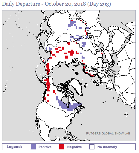
At present, October snow cover expansion is lagging behind climatology over Eurasia. But it’s expanding ahead of schedule into south-central and southeastern Canada. That may bode well for winter getting off to a quick start here by December by maintaining better integrity of Arctic air-masses heading our way.
The relative lack of snow cover over Alaska and western Canada doesn’t concern me. That may be a manifestation of the PDO+/PNA+ pattern which is usually favorable for cold and/or snow here.
One more thing…
The waters offshore from the eastern United States are pretty warm:

This could mean more latent heat available to crank up coastal storms. Of course, this only translates into big snows if cold air is in play, pending the actual storm tracks.
Bottom line
Most winters that are remembered for snow and cold have their ebbs and flows. The truly great wire-to-wire winters of 1993-94 and 2002-03 are magical white unicorns. If you chase the white unicorn, you’ll never get out to ride your snowmobile.
Besides the slow-ish expansion of snow cover over Eurasia, I don’t see a lot of flashing red lights to indicate gloom and doom for the upcoming winter yet.
Give it time to play out and see what happens. Just be ready to ride when the time comes. 🙂
Keeping up with my updates this winter
I will tend to post about long range weather patterns on the main website. For more time-sensitive storm updates and random things that pop up in my head at 3am, I’ll post on the Facebook page which is found here: www.facebook.com/ilsnowcom

Make sure that you:
- Click the Like Button (if you haven’t already)
- Under Following, set to “See First” in your news feed & set notifications “On”
This will give you a fighting chance of being notified of my updates on Facebook.
For the ilsnow nation,
Darrin
This report is brought to you by Steet Ponte Auto Group. Many of the vehicles here in Indian Lake are bought from the Steet Ponte. Co-owner Joe Steet is a huge fan and booster of ilsnow.com. If you’re looking for a new truck, give Steet Ponte a good look.