I was highly skeptical of the good ole fashioned “out to sea” idea for Wednesday’s storm and took the trouble to explain why this was our first legitimate prospect for widespread significant snow fall for the Adirondacks this season.
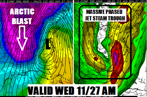
The shorter range NAM model is starting to merge with what the ECMWF model is showing for Wednesday AM:

That’s a very impressive storm with tons of moisture streaming our way. In the heart of winter, this would be a major foot-or-more snowstorm for all of ilsnow land. Unfortunately, this is late November and the rain-snow line has pushed all the way up to Pottsdam/Watertown line by Wednesday morning, according to the above panel.
Part of the problem is that we don’t have a high lattitude blocking pattern in the Canadian Maritimes to lock down the cold air. Another part of the problem is that the atmosphere in late November simply isn’t going to be as cold as it would be in the heart of winter for the same situation. There are reasons why major foot-or-more snow storms are rare in November, outside of the lake effect snow belts and high mountains. And this is a classic example of why.
However, this storm is not a lost cause by any means. There should be an initial surge of moderate to heavy snow Tuesday night before the relatively milder air wins out by Wednesday morning. Temperatures on Wednesday will only top off in the lower to middle 30s in most places. Then, cold air crashing into the backside of the storm Wednesday night will result in further accumulating snows.
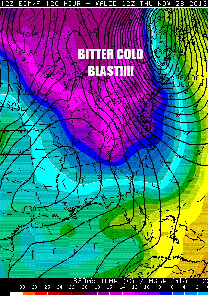
On Thanksgiving Day, we’ll have this behind the storm:

Temperatures will fail to make it out of the teens on Thanksgiving Day in the heart of the Adirondacks with well-below-zero wind chills, very impressive stuff for late November!
Overall, this storm should be a net plus for us, laying down the foundation for the base we’ll have this winter to ride on. After Thanksgiving Day, the overall pattern favors cold weather well into the first half of December. If you’re a weather geek and can navigate through the alphabet soup of PNA, NAO, AO, WPO and EPO, you can check out this excellent discussion by Dave Tolleris at WXRisk.
By now, you should have a really good idea of why I don’t play the game of forecasting snow amounts more than a couple of days before a snow event. The hard truth is that the models simply do not have the ability to accurately pinpoint storms more than a couple days in advance, most of the time. The best we can do is recognize the pattern, watch for trends, then dial in the details as the event draws closer.
If the scenario I painted this evening is correct, I think most of ilsnow land will get at least 6 inches of snow between Tuesday afternoon and Thanksgiving Day with this storm. If the orographic snows go crazy on the back side of the storm, there could be significantly more snow over the northern/western Adirondacks. Again, these are details to be filled in once the entirety of the storm enters the shorter range models.
If it was easy all of the time, it wouldn’t be much fun. 😉
Darrin @ ilsnow.com

