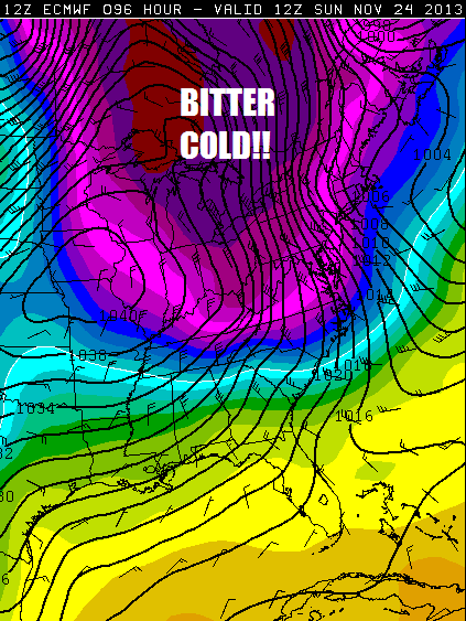
The Arctic Oscillation is starting to shift and I believe that may lead to our first widespread significant snowfall of the early winter season by the middle of next week. Before we get into any talk about big snow, there is a major cold blast to talk about for Sunday the 24th.
This is an IMPRESSIVE for late November: WOW!

Temperatures would have a tough time cracking 20*F in the heart of the Adirondacks, if at all on Sunday. With air that cold pouring over the Great Lakes, there will be lake effect snow squalls and whiteouts. However, rapidly shifting winds and limited low level moisture should prevent major accumulations.
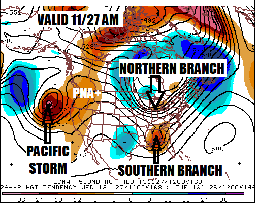
The brunt of that bitter blast will not last for long, but the air left behind should be cold enough for snow when opportunity knocks by the middle of next week. I have outlined the major players:

Let me get a caveat out of the way: There is NO Greenland Block with this setup. The North Atlantic Oscillation will be neutral at best. However, that doesn’t rule out a significant snowfall any more than having a Greenland block guarantees a big snow storm. Plenty of big snows have occurred with a neutral or even positive NAO. There are other factors that determine whether a storm hits or misses us.
If this was a case of a strong Pacific jet slamming into the United States, I would say this storm has ZERO chance, like the “storm” last week that was played up by the media hype machines, but never happened because the strong Pacific jet shoved it out to sea.
But that doesn’t appear to be the case this time. All of the Pacific jet energy should be bundled in that Pacific storm to the west of California/Oregon. As a bonus, the Pacific storm pumps up a ridge over the western United States (PNA+). The PNA+ also increases the amplitude of the eastern United States trough, which MAY bring the northern and southern branches of the jet stream close enough to phase into a big storm.
In my opinion, these two things need to happen to produce a significant snow event for us:
- Pacific storm needs to be there, to pump up the PNA+
- Southern branch jet stream disturbance needs to be strong enough to force the northern branch to merge with it.
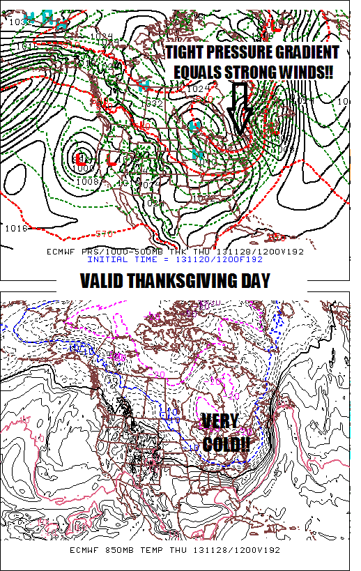
If one or the other doesn’t happen, this storm isn’t happening for us because we won’t be getting any help from the NAO. We would have some minor snows as the northern stream disturbance slams through. With or without the storm, Thanksgiving Day is going to be very cold and blustery:

So there you have it, the first legitimate prospect for a widespread snow event this season. Nothing is ever a lock 7 days away, but I’d say this has a chance. Looks like I’ll dust off the ilsnow.com storm center console and fire up the daily weather forecasts soon. Who’s ready? 🙂
Darrin @ ilsnow.com

