I’ve been stringing along the Winter Outlook for a while. So it’s time for me to put up or shut up.
First, let me get the disclaimer out of the way: This outlook is a general idea of what I think this winter might do. It is impossible to predict individual storms, cold surges and thaws months in advance. This outlook should NOT be used to plan a snowmobile vacation.
Over the course of the winter, I will comment on significant weather pattern changes as they occur.
With that out of the way, let’s dig in and take a look at some factors!
December:
Winter has been slow to get off the starting blocks in the past few years. November 2013 has been marked with large temperature swings; impressive cold interspersed with periods of milder weather. That trend will continue through November, but the Arctic Oscillation is expected to take a nosedive in the next couple of weeks. This will no doubt, reshuffle the cards!
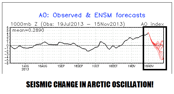
With the Arctic Oscillation tanking toward neutral or negative, cold blasts should begin to have staying power. By the end of November, the ensembles are showing a PNA+/NAO- pattern with the Canadian polar vortex pancaked in the middle:

Winter is likely to get a better jump than it has in recent years. By early December, much of the central and eastern United States could be rolling in the cold!

This certainly opens up the doors for lake effect snows. Some of the ensembles are hinting at a widespread snow event around the first week of December.
Factor rating:
Probably no worse than neutral, could be PLUS if things break right.
October Siberian Snow Cover:
In recent years, the spread of Siberian snow cover in October has been on the cutting edge of long range winter forecast discussions. The theory: a large October Siberian snow pack is often linked to a prevalent negative phase of the Arctic Oscillation in the winter, which allows for more frequent penetrations of Arctic cold into the United States and more opportunities for snow. A smaller October Siberian snow pack is often linked to a prevalent positive phase of the Arctic Oscillation in the winter, which tends to bottle up the Arctic cold way up north with less opportunities for snow here.
The following table showed that Eurasian snow cover for October 2013 ranked #4 out of the past 46 years. That’s impressive! But I must say that some of this explosion of Eurasian snow cover was in central China instead of Siberia. That being said, the growth of snow coverage over Siberia was still quite healthy:
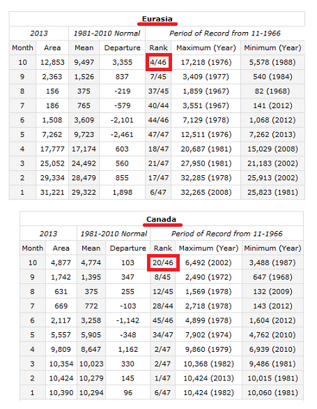
Snow cover growth over Canada in October 2013 was modest, ranking #20 out of the past 46 years. But the first half of November has seen a big surge in Canadian snow cover:

The bottom line is that North Hemispheric snow pack has been expanding at a rate that suggests healthy snowfall for ilsnow land this winter.
Factor rating: PLUS!
North Atlantic Oscillation (NAO):
Almost every weather geek keeps track of the NAO index like some people watch the DOW Jones index. Unlike DOW Jones Index, we want that NAO to go low, low low!
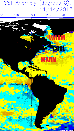
The North Atlantic Tripole (warm-cool-warm) appears to favor the negative NAO for this winter:
A method has recently come to my attention that is reportedly extremely accurate in regards to forecasting the prevailing NAO for the winter. Perhaps of significant importance, this method is forecasting a strongly negative NAO for this winter. You can read more about it at WXrisk.
Factor rating: PLUS!
Pacific Decadal Oscillation (PDO):
North Atlantic Oscillation gets all of the attention. But what happens in the Pacific Ocean is equally as important! You can get a decent primer on what drives the PDO here:
Roughly speaking, a strongly negative PDO indicates colder northeast Pacific Ocean, stronger Pacific Jet stream, more frequent thaws. A strongly positive PDO indicates warmer northeast Pacific Ocean, weaker Pacific jet stream, more frequent cold blasts.
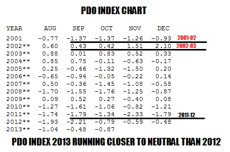
This PDO table shows it pretty clearly:
2001-02 was a very lousy winter, well noted for it’s record warmth and lack of snow. Look at the PDO index going into the winter: Highly negative!
2002-03 was a great winter from start to finish. The fun started in November and carried on well into April. The PDO index going into that winter was highly positive!
2011-12 was another lousy winter. PDO index going into winter:
Extremely negative!
The average PDO index for Aug-Sept-Oct 2012 was -1.64. The average Aug-Sept-Oct PDO index for 2013 was -0.80, which is much closer to neutral than it was last year.
I suspect that the November PDO index will take a leap toward neutral because the northeast Pacific has warmed up over the past couple of weeks:
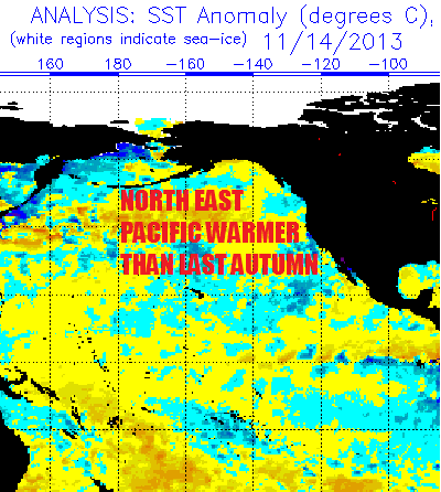
Bottom line is that PDO should be less hostile toward us than it was last year when winter got off to a late start in December followed by two crushing thaws in January.
Factor rating: Neutral
El Niño-Southern Oscillation (ENSO):
Most of the ensemble members are clustered toward neutral though this winter with a slight rise toward weak El Niño:
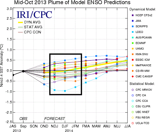
If the ENSO does indeed crack into weak El Niño (around +0.5) later this winter, February and March could be big snow months! Strong El Niños (ENSO+) and strong La Niñas (ENSO-) scare me because they have loused up many a winter. I don’t see that here.
Factor rating: Neutral, perhaps PLUS!
Highlights:
- Winter should make its presence known much quicker in December than it has in the past few years.
- More opportunities for snow and cold, less threats of major thaws than last winter.
- Temperatures December-January-February, on the whole, should average normal to somewhat colder than normal.
- Snowfall December-January-February, on the whole, should be somewhat above normal.
- Lower elevation places outside of the Adirondacks and Tug Hill should actually have a solid riding season, unlike the past two winters.
- My guess for Indian Lake snowfall October 2013 – April 2014: 115-130 inches
Despite most of the factors shading toward our favor, I’m NOT going crazy on predicting an all-time great winter. Most of those winters, like 1993-94 or 2002-03, knocked down the doors in November. We’re not off to that kind of start. If December is a PLUS month for us, I think we’ll be on our way to a solid winter here. Even if December or January turns out to be a bust, I think we could still do well on the back side of winter.
As always, we’ll see what happens!
Darrin @ ilsnow.com


