Last week, I started talking about a major pattern shift that would bring much colder weather here before the end of October.
The proof is always in the pudding and changes are already underway. In layman’s terms: the dominoes are starting to fall!
The warmth that has dominated October will begin to give way to weather much more typical of mid to late November. Yes, I do believe there will be snow in the air over ilsnow land by the end of next week.
What’s going on now?
After a slow start, snow is starting to build nicely over northern Canada:
What’s going to happen?
The GFS ensemble plot shows major PNA+ pattern with strong ridging up to Alaska. This in turn will promote a trans-Siberian flow that will power drive Arctic cold air over the North Pole into Canada. Over the next 1-2 weeks, we’ll see a rapid buildup of snow cover over central and eastern Canada:
When will we see snow at the ilsnow storm center?
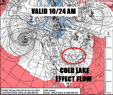
I believe that will happen by Thursday or Friday of next week (24th/25th). Today’s Canadian GEM was depicting a broad lake-effect precipitation pattern by this time frame:
Most of the model ensembles are showing a 1000-500mb thickness of 528 decameters over the central Adirondacks at this time. I know this is pure weather geek terminology, but the lower the 1000-500mb thickness, the colder the atmosphere. In my experience, 528 decameters is usually cold enough for snow at Indian Lake, regardless of how early in the season.
The build up of snow over central and eastern Canada will be key to prime the “cold pump” enough for snow to make it to the ground. It would be silly for me to speculate on possible snow accumulations a week away from a potential event, so I won’t! 🙂
After that?
Well, the Climate Forecasting System ensembles are showing a massive cold anomaly over the central and eastern United States into early November:
Interesting to note that Alaska will be much WARMER than normal. This demonstrates that our cold air does not usually originate from Alaska, but rather from the trans-Siberian connection over the North Pole into Canada. A couple of winters ago, the cold weather was bottled up in Alaska, with villages literally getting buried under snow. Meanwhile, we were left with a mild and paltry winter with the body of Indian Lake losing its ice by March 26th!
If the developing weather pattern for late October/early November holds into the winter, we’ll get off to a great start. As mentioned in my previous post, the rapid buildup of snow cover over Siberia so far could be great sign for us. An excellent read on this correlation can be read here.
As always with the weather, we’ll see what happens! I’m looking forward to winter getting out of the starting blocks more quickly than it has in recent years.
Darrin @ ilsnow.com


