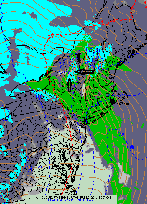
The upcoming storm will be a ONE-TWO combination. You can see the two players here Friday morning. Storm 1 is for Friday. Storm 2 is for Saturday:
Friday:
There are 2 notable things about Storm 1:
1. Marginally cold air in place.
2. STRONG southeast flow as shown by the tightly packed black lines.
These are keys to the forecast. A strong southeast wind will enhance precipitation and result in slight cooling east of the Adirondack spine. Conversely, it will hinder precipitation and result in slight warming west of the Adirondack spine. When the temperatures are marginal (borderline between rain and snow), this setup could result in a “private” snowstorm for Indian Lake, Speculator, North Creek and Newcomb while Old Forge, Inlet, Raquette Lake, Tupper Lake and Long Lake get mostly rain. In fact, the 18Z Meso-NAM is showing exactly that by mid-Friday morning:
In the end, I think the mild southeasterly flow will overwhelm the private snowstorm with a changeover to rain by noon. But there could be several hours of moderate to heavy snow before that happens. Colder air will return from the west late Friday, but the meat of Storm 1 will be leaving by then. Forecasting snow amounts will be tricky because because a degree or two can mean the difference between an inch of slop and 6+ inches of snow, NO LIE!
Saturday:
Storm 2 will wobble its way through the North Country on Saturday:
The air won’t be tremendously cold, so we’re talking more about “lake enhanced” orographic snows as opposed to true “lake effect” snow. This is when Tug Hill and the western Adirondacks will score most of their snow. Winds will increase on Saturday and it will actually feel somewhat like winter. 🙂
Bottom Line:
Remember what I said on Sunday: This is going to be a crap shot! In the end, I think we’ll get a few places to ride by Saturday or Sunday. But expect MARGINAL CONDITIONS if you come up to ride and make sure you verify there is ride-able snow BEFORE you make the trip!
Beyond the Weekend:
There is already hype about a post-Christmas storm and the weather pattern thereafter. More on that later……


