I upset more than a few people with my recent outlook for December.
Please understand: I’m just calling it as I see it. I don’t peddle false hope just to keep people happy. My job is get it right or go down in flames trying to get it right.
Now that we got the stomach kick out of the way, it’s time to assess the situation and see if we can find a glimmer of hope for 2013.
When I issued my Winter 2012-13 Outlook in October, I was pretty certain that November wouldn’t have much snow. Unfortunately, December is starting to look like a wash as well. The chief culprit is a howling Pacific jet stream, supported by a large pool of cold water over the eastern Pacific (Box 1). In case you are wondering about El Niño, it’s a non-issue. The equatorial Pacific (Box 2) is showing near neutral conditions:
A strong Pacific jet results in lack of cold over the United States. The snow cover does not lie. Here is a comparison of December 10th snow cover between 2011 and 2012:
You can see the utter lack of snow cover over the eastern United States both years! But there is one huge difference: Note the large expanse of snow cover over Europe this year as opposed to last year. That is a manifestation of the strong negative Arctic Oscillation, which is opposite to the strong positive Arctic Oscillation that we had last winter. It is important to note the Arctic Oscillation and North Atlantic Oscillation are NOT the same as last winter.
The Arctic Oscillation has trended strongly toward negative since October 1st.
Last year is was strongly positive.
North Atlantic Oscillation has been mainly neutral to negative since October 1st.
Last year is was strongly positive.
So, the hemispheric pattern is not the same as last year although the weather feels the same around here.
Is December a lost cause?
Let’s get one thing straight: December 2012 on the whole is going to be warmer than normal. But that doesn’t mean it can’t snow.
One way that we can get meaningful snow out of this pattern would be to divert the Pacific jet southward to California, instead of British Columbia.
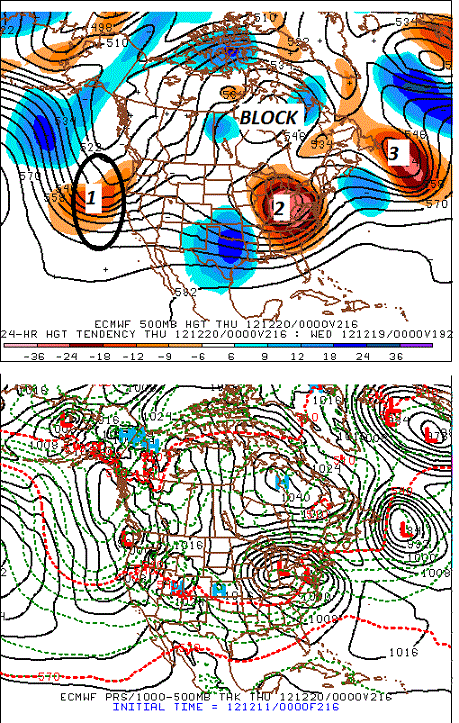
Last night’s ECWMF is showed a possible significant snow or mixed precipitation event by the middle of next week with that scenario.
You can see:
1. Storm in the Pacific jet crashing into California
2. Storm approaching northeast United States
3. Storm offshore Newfoundland
4. Blocking high over Hudson’s Bay
This is an active pattern! If the blocking high and the California Pacific jet track are correct, approaching storms will be forced to “go coastal” with a much better probability of snow. If the Pacific jet continues to ram British Columbia, there won’t be a block over eastern Canada and the storms will continue to track to our west with nothing but rain. It’s a crap shoot for sure. But that’s better than no hope at all. 🙂
What needs to change for 2013?
The Pacific jet needs to weaken. With that strong pool of cold water over the eastern Pacific, it’s going to take time. Dave Tolleris of WXRISK does a great job explaining how this could happen by the New Year.
Revisiting October Eurasian Snow Cover
Strong growth of Eurasian snow cover in October has been linked to heavy snow in the eastern United States. Let’s take a look at what happened here during the 4 snowiest Eurasian Octobers in the past 20 years:
1998: Not much snow in November and December. (Sound familiar?) Then monster snows in January and March (over 40 inches both months at Indian Lake)
2002: Great winter from wire to wire with a big finish in April!
2006: Green Christmas. Limped through January and early February, then bang!! Valentine’s Day Blizzard and it kept going well into April.
2009: On the whole, it was a dud winter around here. But the Adirondacks got hit with back-to-back snowstorms toward the end of February. In a weird twist, it was one of the snowiest winters on record for the middle Atlantic region on the strength of successive major snowstorms in February.
With the exception of 2009-10, each of the follow up winters featured at least 2 major snowstorms (defined as 1 foot or greater) in the central Adirondacks. Three out of four isn’t bad.
October 2012 ranked 5th in Eurasian snow cover in the past 20 years. That’s pretty good company. 🙂
For giggles, I pointed out October 1976. The winter of 1976-77 was legendary with Old Forge setting its all time seasonal snowfall record of 408 inches!
Summary:
There is potential for a reversal in 2013 based on:
1. Prevailing negative Arctic Oscillation (NOT the same as last winter)
2. Anticipated weakening of the Pacific Jet
3. Healthy October Eurasian snow cover
At least we have some hope this time. I don’t think we’ll have a particularly cold winter, but I still think it will end up considerably more snowy than last winter.
BIG CAVEAT: If the Pacific jet fails to weaken or we flip into a long duration positive Arctic Oscillation (AO+), we’re screwed just like last winter.
Keep the faith! We’ve still got January, February and March to turn it around.


